Site of first The Basin Fire station
opened in 1953.
In 2002, commercial property.
First
Basin Fire
Station
Circa 1952
(Click to Expand)
Site of second The Basin Fire station
opened in 1967. This was later demolished and the current
(third) station opened in1977.
Stone wall. Originally built by
sustenance workers during the depression of the 1930's.
Has been repaired a number of times since then.
Site of Log loading bay used between
1936 and 1940. A bullock team pulled the logs down to the
high bank of Mountain Highway and the logs were rolled
into a truck.
When Inverness Avenue was first created
in the Schneider's Estate, the top end could not be
accessed from either Claremont Avenue or Mountain
Highway. From Claremont Avenue, there was no creek
crossing (created in 1984) and from Mountain Highway
there was no official access until this block of land was
purchased in the 1950's.
Previous to this, a track was created by residents to
gain access from Mountain Highway (see Places of Interest
110).
Site of old quarry. The location can be
easily pinpointed as the roadside margin has a peculiar
bend around the site. Not known who owned it or when it
started operation, but it was used as a source of stone
for local roads.
Not used after about 1935.
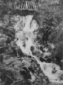
Griffith's Falls. Also known as Ferndale
Falls or The Basin Falls.
Griffiths
Falls
Circa 1915
(Click to Expand)
Oak tree planted in 1875 by William
Chandler. One of the finest specimens of English Oak in
Australia.
Also site of Centenary cairn erected by the Chandler
family as part of The Basin centenary celebrations in
1967.
Site of training and trotting tracks
known as "The Trotto" built by J. J. Miller.
In 2002, residential property.
Site of a lookout known as Barne's
lookout until 1927 when T. M. Burke, a local Real Estate
Agent, presented 7 acres including the lookout to the
Crown to be used as a public park. He also asked that it
be known as Burke's lookout from then on.